Post by Brick Tamland on Feb 18, 2020 23:05:25 GMT -5
Ready for a huge snow storm here. NAM has been consistent and unwavering. All the other globals are trending to the NAM except the Euro. I don't get why the local mets here are hugging the Euro when it appears to be alone. I would go with the majority of the globals and the NAM over one global model.
Raleigh has stuck big accumulations into its Coastal Plain Forecasts. The Thursday night Point-and-Click forecast for southern-most Edgecombe County -- just a couple hundred yards north of my house -- now says "New snow accumulation of 6 to 10 inches possible." I guess Raleigh is facing the model music. Not sure they're right, though.
Raleigh has stuck big accumulations into its Coastal Plain Forecasts. The Thursday night Point-and-Click forecast for southern-most Edgecombe County -- just a couple hundred yards north of my house -- now says "New snow accumulation of 6 to 10 inches possible." I guess Raleigh is facing the model music. Not sure they're right, though.
OK, Raleigh has fixed its boo boo. At 4 a.m. the double-digit snow forecasts now say "around an inch possible." I wonder how such a spectacular snafu was ever allowed to reside on the servers for so many hours.
Raleigh has also, as of its 4 a.m. discussion, tossed a barrel of cold water on snow prospects. They are expecting 1" to 2" max, in the NE coastal plain, and less elsewhere. And MHX isn't jazzed, either -- 1" to 2" max.
lets see what the NWS does now that the Eur who they are hugging to death went wetter with 3-4" snow over us now....I suspect this will increase some today as well....06Z NAM had around 17" for Greenville lol....
Raleigh has stuck big accumulations into its Coastal Plain Forecasts. The Thursday night Point-and-Click forecast for southern-most Edgecombe County -- just a couple hundred yards north of my house -- now says "New snow accumulation of 6 to 10 inches possible." I guess Raleigh is facing the model music. Not sure they're right, though.
OK, Raleigh has fixed its boo boo. At 4 a.m. the double-digit snow forecasts now say "around an inch possible." I wonder how such a spectacular snafu was ever allowed to reside on the servers for so many hours.
Raleigh has also, as of its 4 a.m. discussion, tossed a barrel of cold water on snow prospects. They are expecting 1" to 2" max, in the NE coastal plain, and less elsewhere. And MHX isn't jazzed, either -- 1" to 2" max.
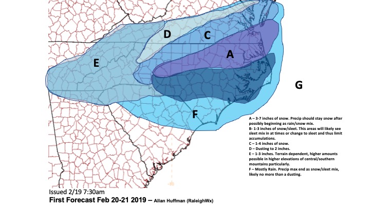
Local NWS offices, for whatever reason, rely heavily on globals like the Euro and GFS for their forecast. This imo is irresponsible inside 48 hours and why they’ve been burned so many times in recent memory on systems. The 3km NAM is designed specifically for handling the various processes in play here. NWS RDU says temps will be an issue but the 3km crashes temps quickly to 32F once good precip rates get going (in contrast to the slower globals). This makes sense given the soundings and expected heavy precip moving in. Regarding precip, the 3km 6z run ticked up considerably and has nearly 1” to work with for RDU to Wilson and 1-1.5” east of there. Even assuming a paltry 5:1 snow ratio, which is too low imo, that yields 4-5” of snow for rdu and 5-8” for Wilson to Greenville. I get it that they are skeptical but I’ve seen them also get burned when bullish based on global output while ignoring the 3km nam and getting burned there too. That storm a few years back comes to mind where the mixing line pushed well NW of RDU but they were forecasting 4-8” for many areas that only saw 1-2” of snow. Ignoring the 3km thermals is a bad move by any NWS agency, it is my go to model inside 48 hours and has proven itself many times in these setups. Some recent upgrades have also seemed to help the NAM suite with overall qpf output accuracy.
Ready for a huge snow storm here. NAM has been consistent and unwavering. All the other globals are trending to the NAM except the Euro. I don't get why the local mets here are hugging the Euro when it appears to be alone. I would go with the majority of the globals and the NAM over one global model.
Welcome Brick! I think you’re sitting in a good spot for this storm if the mixing line can stay south of Raleigh. NAM has a solid 6-10” event for your area depending on which version you look at. If NAM holds or trends colder today I will feel good about the idea of the 264 corridor being the transition zone or just south of there.
lets see what the NWS does now that the Eur who they are hugging to death went wetter with 3-4" snow over us now....I suspect this will increase some today as well....06Z NAM had around 17" for Greenville lol....
They’ve been burned so many times by hugging the Euro and ignoring the 3km NAM. For the life of me I have no idea why they don’t seem to value it’s output at this stage and prefer a lower res global.
Here is the latest discussion from Wakefield. Just pertinent info only.
Given the trends of bringing the pcpn shield farther north with each model run, snow totals with this forecast package will range from arnd 1 inch in the RIC-PTB metro areas east towards MVF, a 1-2 inch swath farther se towards the middle Peninsula to FKN-AVC with 2-3 inches in areas away from the water across Hampton Roads/nern NC. These values are still in a winter wx advsry headline if they hold, but watches may be needed if amounts tick up in later model runs.