Post by snowlover91 on Aug 31, 2016 0:09:37 GMT -5
We still may see some interesting weather from this. If it goes inland like the CMC it will be transitioning to extra tropical and interacting with an approaching front. This would beef up rain totals along and just NW of the track. The CMC actually indicates sustained 30-35kt winds across a good portion of Eastern NC with gusts into the 40s and low 50s. Whether it takes that track or not remains to be seen. Also a solid 6-8" of rain falls on the CMC and navgem. Euro would probably be similar with its track.
The New England guys are gonna start freakin out if the CMC and Euro keep showing the retrograde back into the New England area after 99L leaves the Southeast.
Post by Fountainguy97 on Aug 31, 2016 7:39:48 GMT -5
No way this isn't a TS yet. Models still split on strength BUT the 4k NAM takes it to a MB of 927!!! Lots of potential with this system and with it about to go through some RI we may very well be looking at a hurricane tonight
I dunno if I would say it was about to undergo RI, its still not completely stacked and regardless of how strong it gets now the shear it hits when it gets north will hurt it pretty bad....intensity is difficult to predict and it had several other flare ups like this overnight that faded.....I would suspect 75-90 mph at landfall would be upper end of what is possible given the shear setup, unless it manages to get to Cat 2 before it hits the shear and the thing isnt that organized its a 40-45mph TS at best right now.....once it gets up this way it will be weak on the west side....so rainfall and especially wind should be limited to the coast....if it tracked far enough inland to put us on the east side the storm would be a TD at best by the time it got up here. our best bet would be for it to get 100 miles off the east coast and then bend back NNW and come in over NC...basically like the GFS has it doing north of NC....just need that to happen sooner....so we end up with 2-3 " of rain and 20-30 mph gust if we are lucky...unless something drastic changes with the reasoning.
Post by Fountainguy97 on Aug 31, 2016 9:33:14 GMT -5
Models are spread out on intensity the weakest is like 980mb at landfall while the 4KM nam for several runs has had a sub 930mb storm.
I disagree about limited the precip to the coast. Basically every model has the storm transitioning into a much larger system as it comes over land. It develops a giant NW rain shield. CMC drops over 6 inches.
Also there is a weak frontal boundary that could potentially increase moisture. that is evident on the 12z NAM run with the big shield of precip well away from the storm at hour 51. Any interaction between the two could produce some impressive rainfall not to mention slowing the system down.
Also remember if someone ends up getting 10+ of rain from this, (not necessarily us) in a week and a half we have another possible storm approaching
This is the 12z 4km nam with a 927mb storm. Regardless of strength tyler has pointed out the front and highlighted rain area. Notice all the convection to the North East of the system already front interaction is occurring.
Last Edit: Aug 31, 2016 9:39:22 GMT -5 by Fountainguy97
Post by snowlover91 on Aug 31, 2016 10:17:18 GMT -5
This could pose a significant impact to NC with rain and decent TS force winds. My current thinking is this will undergo decent strengthening today and RI sometime tonight or tomorrow morning then slowly strengthen up to landfall. One thing to consider is that the increasing shear of the trough will be oriented SW to NE, the same direction TD 9 is moving. This will lessen any impact of the shear and could actually help it "vent" by providing a nice outflow channel to the NE. One of the best examples of this was charley as it rapidly intensified to a category 4. The trough setup and angle of shear is similar with this storm so I don't think shear will be much of an issue.
Here is where things could get interesting. I sent Preston the pic above showing my concerns. The blue line represents the front or "wall." As the moisture streams up from the south it will hit this front and enhance the lift over NC and SC. This could easily produce widespread 6-8" amounts like the CMC, EURO and NAM now show happening. I expect the 12z GFS to begin picking up on this as well. One last thing, it will be transitioning to extra-tropical and phasing with the trough as it heads our way. The NAM fully phases it over NC which would temporarily deepen the storm while expanding the wind field. Widespread TS force winds or gusts would be likely in this scenario.
Post by snowlover91 on Aug 31, 2016 10:47:58 GMT -5
As expected the 12z GFS is coming in slower, stronger and further west with TD 9. It now aligns well with the above mentioned models and the significant rain threat is increasing. I doubt we see too many flooding issues due to the dry ground but if 8-10" of rain falls like some models are indicating then localized flooding is possible. Here is the 12z GFS run.
Last Edit: Aug 31, 2016 10:49:07 GMT -5 by snowlover91
The track on the midday GFS is highly unusual for a tropical system (and would be surprising for a winter system too). Up the coast on an inland trajectory to across the middle of the Chesapeake Bay .... can't recall ever seeing a track like that before, at any time of year. Well, once about 30 years ago with an October nor'easter but nothing in more recent times.
Very interesting!
Every normal man must be tempted at times to spit on his hands, hoist the black flag, and begin to slit throats. H.L. Mencken
All 3 major models are all west of us up the I95 corridor with hermine now. That's quite a shift west. If it takes that track it will increase a tornado risk for sure. East side is always worse for tornados.
As far as any RI goes I'm skeptical. They are saying on TWC that this has a huge circulation. That may bode well for us for our impacts but large circs have a harder time ramping up super fast. It's not impssible but less likely than a tight wound up core.
Larger circs also wind down more slowly that could allow us to have some decent wind gusts if it does track west of us as all major models now show
Ummm is it just me or does the euro loop this thing off the east coast and had an intensifying storm approaching NC dropping g wsw at 991mb? How crazy would that track be wow.
Looks like the euro turns it back ne at the last second and starts to bomb it out. If that storm sits there for 3 days off the east coast the erosion and beach damage will be significant for the entire east coast.
Ummm is it just me or does the euro loop this thing off the east coast and had an intensifying storm approaching NC dropping g wsw at 991mb? How crazy would that track be wow.
Yeah we need to watch for the phasing with the trough, if this does occur the low will stall out or rotate around the trough. Models differ on where this happens though. The NAM does it over VA and northern NC while the Euro and GFS do it much further north.
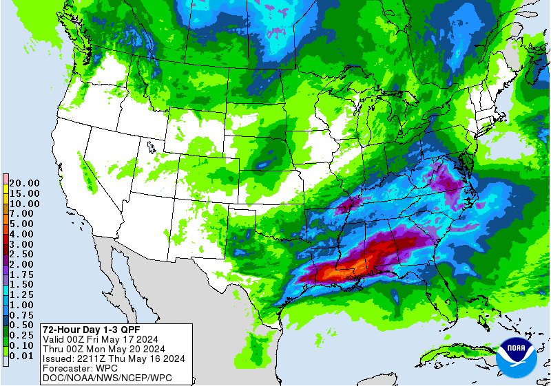
I'm sure Bozart will have something to say about the HPC rainfall map
Take any WPC forecast total for your locality, then cut it in half, and cut it in half again. Based on that tried-and-true formula, I expect an inch. And that'll be fine.